Wednesday, March 30, 2005

Plants on Ubin

Yet another informative extract from Edmund Waller (2001) "Landscape Planning in Singapore".

With regard to flora, the human interference on Pulau Ubin has led to semi-natural vegetation dominated by relatively few early successional species and 21% of alien species.

The Ubin flora represents about one eighth of the total flora recorded for Singapore and is made up largely of common weed, secondary forest and mangrove species.


In a recent survey (Turner, 1993), only one real rainforest tree was discovered. The author states that from a Singapore standpoint, the patches of belukar and mangrove are of value in a country with so little natural vegetation remaining.

---------------
References:
  • Waller, Edmund (2001) "Landscape Planning in Singapore" (Singapore: Singapore University Press) pp.165-171
  • Turner, I.M. et al. (1993) "A Botanical Survey of PUlau Ubin" Department of Botany, National University of Singapore
  • Tuesday, March 29, 2005

    Water Supply

    An extract from Edmund Waller (2001) "Landscape Planning in Singapore".

    Permanent streams are rather rare at Ubin, but a notable exception is the stream at Kampong Melayu that provides some of the water for the village and formerly for the many houses, now in ruins, which are situated near the banks of the stream. Streams have also been dammed up to provide a water supply for the Outward Bound School.

    Other fresh water comes mainly from wells, of which the temple well in the centre of Pulau Ubin Village is a prominent example. Sometimes these wells are too close to the sea and suffer from salt water pollution, though some of the islanders swear that the well water is better than mainland tap water.

    Port of Singapore Authority (PSA) water tankers can supplement the fresh water supplies in an emergency, but the existence of a deep marine trench has made it uneconomic to bring a pipeline over from the mainland. The same applies to the supply of electricity.

    ---------------
    References:
  • Waller, Edmund (2001) "Landscape Planning in Singapore" (Singapore: Singapore University Press) pp.165-171
  • Monday, March 28, 2005

    Quarry Lakes

    Yet another tidbit from Edmund Waller's (2001) "Landscape Planning in Singapore".


    Picture 1: Abandoned quarry lakes (Source: Carolyn Chiam, June 2004)

    "There are recently abandoned quarries that are gradually filling up with water (Picture 1). Each year, the water level rises and at the former HDB quarry near the Buddhist retreat - The Thai Temple - (sometimes called the Great Pool of Pulau Ubin) [editor's note: also known as Tian Ci], the water has now reached the brim and overflows into the sea (Picture 2). The other abandoned quarries, with smaller catchment areas, are filling slowly and the final water levels can be expected to fluctuate around the top of the underground water table level which will be close to the surface near the sea, but deeper on the hill tops."


    Picture 2: Water levels at Tian Ci maxed out (Source: Ubin Stories Gallery, 9 Oct 2004)

    ---------------
    References:
  • Waller, Edmund (2001) "Landscape Planning in Singapore" (Singapore: Singapore University Press) pp.165-171
  • Beaches and Mangroves

    A continuation on the natural environment of Pulau Ubin from Edmund Waller's (2001) "Landscape Planning in Singapore".


    Picture 1: Muddy banks of an estuary on Ubin (Source: Ubin Stories Gallery, 5 Sept 2004)

    "... the beaches are either muddy or sandy. If they form the banks of one of the small estuaries, then they are muddy and provide a habitat for mangroves (see Picture 1)."


    Picture 2 (left): A Nipah Palm on Ubin (Source: Ubin Stories Gallery, 5 Sept 2004)
    Picture 3 (right): The natural sandy shores of Noordin Beach (Source: Ubin Stories Gallery, 5 Sept 2004)


    "Further inland, as the water becomes brackish, Nipah Palm ecosystems (see Picture 2) may flourish. Other beaches are essentially sandy and the sand is formed from the granitic rocks. (see Picture 3)"

    ---------------
    References:
  • Waller, Edmund (2001) "Landscape Planning in Singapore" (Singapore: Singapore University Press) pp.165-171
  • Sunday, March 27, 2005

    Flute Rocks

    From: Edmund Waller's (2001) "Landscape Planning in Singapore"

    Few areas of Pulau Ubin are more than one kilometre from the sea and a study of the coastal geomorphology of the islands of Singapore (Swan, 1971:43-61) includes some examples from Pulau Ubin. Some of the rocks exhibit evidence of exfoliation in which the outer skin of the rock peels off like an onion. The exposed granite also weathers into rather unusual vertical grooves or flutes (see picture 1), which interested early geologists such as Logan (1847). These solution grooves often extend below the mean low water mark. A beautiful example of this may be seen at the former "Nature House" (now a Club House) where the naturally sculptured rock has been covered with orange lichens and then partially swalloed by a huge fig tree.

    [editor's note: anybody know this rock and tree? Photos?]


    Picture 1: "Flute rocks" (Source: Ubin Stories Gallery, 5 Sept 2004)

    ---------------
    References:
  • Waller, Edmund (2001) "Landscape Planning in Singapore" (Singapore: Singapore University Press) pp.165-171

  • Swan S.B.StC. (1971) "Coastal Geomorphology in a Hot Humid Low-energy Environment: The Islands of Singapore" in Journal of Tropical Geography, Vol 33
  • Friday, March 25, 2005

    New Changi Jetty


    The new jetty is operational! (Source: Pedal Ubin, 20 feb 2005)

    According to Wild Singapore, the Maritime Port Authority of Singapore released a press statement about the move to the new jetty on 30 December 2004. I blame my being behind the news on the fact that I'm an ocean away. Apparently water does not diffuse information as fast as being there itself!

    Changi Point Ferry Terminal to be operational
    from 5 Jan 05


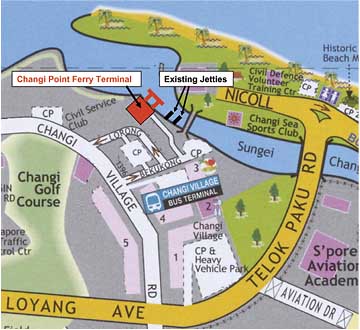
    The Changi Point Ferry Terminal (CPFT) will commence operations on 5 January 2005. With its opening, the ferry and bumboat operations at the existing Changi Immigration jetty and Changi Creek jetty at Changi Village will be shifted to CPFT. These vessels will cease to operate from the existing jetties on 4 Jan 2005, 2359hrs, to facilitate the move to CPFT.

    Located right next to the two existing jetties (please see attached map), the new CPFT was built as part of the Urban Redevelopment Authority's (URA's) environmental improvement plans for Changi Point. It is designed to handle more passengers and offer a user-friendly gateway for both domestic passengers to Pulau Ubin and regional travellers to Pengerang, Johor.

    The new terminal offers a host of new facilities that significantly enhances comfort, safety and security for passengers, compared to the old jetties. These include, among others: Seven berths each for the domestic and regional traffic; Indoor holding areas for domestic and regional passengers; Sheltered gangways and pontoons for safer embarkation and disembarkation; Customs, immigration and quarantine facilities for the regional traffic; Allocated space for two retail operators

    The CPFT consists of an International Terminal (for regional traffic) and a Domestic Terminal. The operating hours for the International Terminal are from 7am to 7pm daily. Domestic passengers will have 24-hour access to CPFT.

    Topography and Geology

    While doing research on landuse planning in Singapore, I came across a book by Edmund Waller (2001), published by the Singapore University Press, entitled "Landscape Planning in Singapore" where there was a section on our northern islands - Pulau Ubin.

    Here's an extract on the natural environment of Ubin.

    "Pulau Ubin is the second largest of Singapore's offshore islands. It lies in the Straits of Johor between Singapore and the Malaysia mainland. It has a linear east-west alignment and is about 7km long and a maximum of 2km wide, giving a total area of about 10 square kilometres. ...

    The topography of Pulau Ubin is undulating and comprises a series of low hills and small river valleys. The hills have slopes of less than 10 degrees generally, and rise to a high point of 74m above sea level at Bukit Puaka in the centre of the island. Other high points include Bt Tinggi (55m) and Tanjong Tajam (55m) in the west, and Pulau Ubin (hill) 11 in the east. In between the small hills are valleys which have been penetrated by small Sungei (rivers) which meander a kilometre or so inland. (see figure 1 - click to enlarge)


    Figure 1 - Topography of Pulau Ubin (Source: Waller, 2001)

    A study of the geological map of the island (figure 2) reveals that the underlying reason for the varied relief is that these low hills are made up of hard granite and associated intrusive rocks of post-Jurassic age [see Geologic Time Table]. The granite hills would have once stood out as small islands within the sea. Now littoral, transitional and alluvial sediments have filled the spaces in between.


    Figure 2 - Geology of Pulau Ubin (Source: Waller, 2001)

    ---------------
    References:
  • Waller, Edmund (2001) "Landscape Planning in Singapore" (Singapore: Singapore University Press) pp.165-171
  • Of Guides and Otters

    Interested in being a Pulau Ubin guide with RMBR's Pedal Ubin?

    Well, Pedal Ubin! is recruiting!

    From: Airani, Pedal Ubin! Project Manager, Raffles Museum Toddycats!

    While the future of Pulau Ubin remains uncertain, development on the fascinating island was put on hold for at least 10 years from January 2002. Right now a group of Raffles Museum volunteer guides have been sharing the stories of Pulau Ubin with the public on bicycle.They call themselves the Pedal Ubin! Jungle Fowls

    Join us! Be a Pedal Ubin! guide! Be a Jungle Fowl!

    Learn about and share stories about the flora, fauna and heritage of Pulu Ubin; e.g. learn how Ubin got its name, the story of the German girl, about the monk who walked from Thailand, the resident family of hornbills and of the plantations that speak of times long past. And how to handle yourself on a bicycle in Ubin.

    Pedal Ubin Guide Training 2005

    We want YOU, but you have to be:
  • a committed individual with a passion,
  • make ALL the training dates below (2005)
  • dedicate minimum 4 saturdays annually
  • have the discipline to come on time,
  • read your emails regularly!

    Training Dates
    1. 14 May 2005 - Classroom session 1
    2. 21 May 2005 - Field session 1
    3. 11 Jun 2005 - Classroom session 2
    4. 18 Jun 2003 - Field session 2
    5. 25 Jun 2005 - Assessment 1
    6. 23 Jul 2005 - Assessment 2 (public guiding)

    Don't worry if you're a novice cyclist. If you can balance
    yourself on a bike and ride steadily, you can certainly join us! Just send an email to: pedalubinguides2-subscribe@yahoogroups.com.

    -------------------------------------------------------------------
    Habitatnews recently reported sightings of Otters on Pulau Ubin!


    Coated otter on Pulau Ubin, ?13 Mar 2004. Photo by MPhil

    Read more about it on the Focus Ubin Forum

  • Friday, March 18, 2005

    Breeder plans 10 fish farms off Ubin

    March 18, 2005
    Ubin Swee Chioh Aquaculture's move to yield 500 tonnes of fish annually for local market
    By Chang Ai-lien
    SCIENCE CORRESPONDENT

    ONE of the biggest fish breeders here has ambitious plans to franchise a high-tech breeding operation that will produce more than 500 tonnes of fish a year for the local market.
    Swee Chioh Aquaculture, well-known for its skills in getting notoriously difficult marine fish to multiply, will set up 10 big-cage farms off Pulau Ubin and franchise them to other companies while providing the expertise, equipment and food supply. Each farm is expected to cost about $400,000 to set up.

    The company also has its eye on opening farms in Vietnam, which it sees as a gateway to the fish-hungry China market.

    It will be its first major foray overseas.

    And as a first step to realising its plans, Swee Chioh, which already produces 250,000 baby fish called fingerlings every month which it breeds and exports to fish farms, intends to double production this year.

    The farms in its Ubin venture will be deeper and larger than what it has now, it said, and there will be centralised feed mills and management systems.

    Managing director Yi Yuan Wah said: 'We're developing an integrated farming system where we have expertise in everything from hatcheries and brood stock management, to cage-farming, research and trading.

    'We want to go big, and do it in an industrialised, commercialised manner, rather than like the small players you see in Malaysia and Indonesia who do not enjoy economies of scale.'
    It is currently working with local fish specialists to better harvest copepods, tiny aquatic creatures that form an important part of the baby fishes' diet.

    In Vietnam, it plans to grow the fingerlings it exports there to full size, producing about 1,000 tonnes of tiger grouper fish a year, on seven farms there.

    Explaining the choice of fish, Mr Yi said: 'The grouper is a sought-after fish, and it's hardy but not easy to breed. That's why the fish are expensive.'

    Breeding the fish calls for years of experience, particularly in fish behaviour.

    The tiger grouper is a voracious eater when small, and a group of 5,000 can be reduced to just 500 within days because the fish eat each other.

    'We've learnt to feed them continuously, so they lose the urge to do so,' said Mr Yi.
    The Agri-Food and Veterinary Authority of Singapore (AVA) said that the company's expansion will help Singapore's efforts to be self-sufficient in food production.

    The Republic is now leveraging on its edge in aquaculture and hatchery research and development to enhance productivity and efficiency in fish farming.

    At the AVA's $33 million Marine Aquaculture Centre on St John's Island, researchers are working on perfecting state-of-the-art techniques for large-scale fish breeding and rearing, in the hope that this work will help produce almost half the fish people eat here.

    By working with commercial partners, AVA aims to increase the amount of fish and seafood produced here to 40,000 tonnes a year within the next decade, or 40 per cent of what people eat.

    Only 5,000 tonnes is produced locally now.

    Monday, March 07, 2005

    Peter Chou: Pulau Ubin & Changi Point

    Visit Peter Chou's B&W gallery of Changi Point and Pulau Ubin which he has published on PBase - 165 black and white photos based on two years of work he carried out at these places.

    "The photos are arranged in such a way that the viewers are brought through the logical sequence of the sights of Changi Point and Pulau Ubin in the form of a virtual tour."